Hidromod and CoLAB +Atlantic Lead Coastal Protection Efforts Through MASCOT Project
Coastal erosion and extreme weather events are among the most pressing challenges for Portugal’s shoreline, threatening communities, infrastructure, and ecosystems. To address these risks, Hidromod, part of ABL, in close collaboration with CoLAB +Atlantic, is driving the MASCOT project (Monitoring and Assessment of Multi-Scale Coastal Hazards). Supported by the Copernicus Marine Service, this initiative transforms scientific data into actionable insights that strengthen coastal resilience.

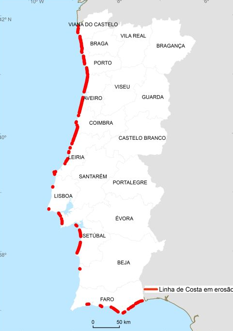
The Landscape of the Portuguese Coast
A large extent of the Portuguese coastal beaches are at risk due to different stress factors such as sea level rising, storms, and human activity which reduce the available sand and weaken the coastline.
In several “erosion hotspots,” already identified by the Portuguese Environment Agency, people, infrastructure, and economic activities are at stake. To address this, solutions such as artificial beach nourishment solutions have been tested.
Key figures highlight the urgency for action:
- 50% of the low, sandy coastline of mainland Portugal is undergoing erosion.
- 1,380 hectares of territory lost between 1958 and 2023 due to coastal erosion.
- €350 million invested in coastal protection and defence interventions over the last 15 years.
- €16 million worth of damage caused to the coastline by Storm Hercules in 2014.
From Information to Action: Solutions from the MASCOT Project
Faced with these risks, it is crucial to anticipate and better understand what is happening on our coastline. Continuously monitoring the state and evolution of beaches, in space and time, is fundamental. But it is also vital to predict storms and flooding in a timely manner to protect citizens and property.
The MASCOT project develops two innovative solutions based on data from the Copernicus European Marine Service (CMEMS), offering practical information that supports local decisions and contributes to the protection of coastal communities, infrastructure, and ecosystems.
Use Case 1: Monitoring Coastal Erosion at Multiple Scales
The objective of this case study is to combine data from the Portuguese Environment Agency COSMO program with information from the Copernicus Marine Service in order to generate knowledge about the current state and evolution of the coastline on any beach along the Portuguese coast.
With this information, it will be possible to produce targeted analyses that support decision-making by local, regional, and national entities, depending on their specific needs.
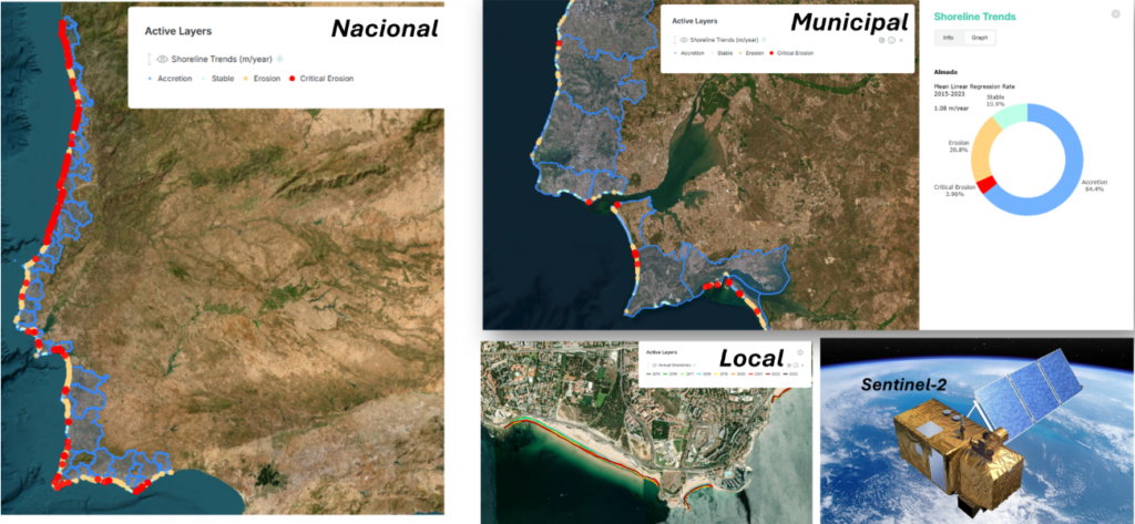
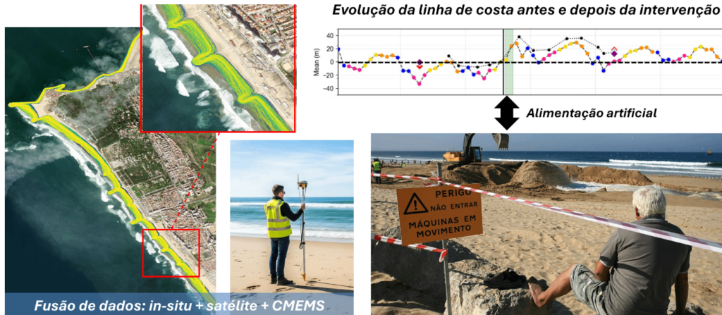
Application: Monitoring coastal interventions at critical erosion points
One application of this monitoring data is to evaluate the effectiveness of coastal interventions on beaches with critical erosion, such as artificial sand nourishment.
With this information, it is possible to understand how long the effect of the intervention lasts, what the impact is along the coastline—both in the intervened areas and in adjacent areas—and to support local entities in assessing the state of their beaches.
Use Case 2: Predicting the Impact of Extreme Events on the Coast
Storms, storm surges, and coastal flooding put communities, infrastructure, and ecosystems at risk. The MASCOT project develops advanced modelling tools, powered by data from the Copernicus Marine Service, that simulate the behaviour of storms in the ocean and their effect when they reach the coast. In this way, we can anticipate when, where, and with what intensity a storm may affect the Portuguese coastline.
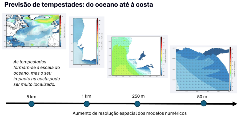
Application: Operational forecasting of coastal flooding
With these high-resolution models, the MASCOT project demonstrates how it is possible to predict where and with what intensity coastal flooding may occur.
This forecasting capability allows for timely mitigation measures and strengthens the safety of coastal populations and infrastructure.
Application: Flood Risk Mapping
Another application of these high-resolution models is risk mapping, such as the creation of maps of flood-prone areas in the face of extreme events with long return periods.
This information is essential to support adaptation measures that help reduce the risk associated with rare but high-intensity phenomena.

A Collaborative Effort for Coastal Resilience
The MASCOT project is developed by Hidromod in collaboration with CoLAB +Atlantic, combining expertise in ocean modelling and applied research to deliver practical solutions for coastal protection.
This partnership exemplifies how innovation and cooperation can turn data into actionable strategies that safeguard communities and ecosystems.
Looking Ahead
As climate change intensifies, projects like MASCOT demonstrate the power of science and collaboration in building resilience. By integrating advanced monitoring and predictive modelling, Hidromod and CoLAB +Atlantic are paving the way for a safer, more sustainable future for Portugal’s coastal regions.